| Anchorage Name | Location (Coordinates) | Area (km²) | Depth (m) | Bottom Type | Max Vessel DWT | Capacity | Primary Use | Restrictions & Safety Notes | Commercial Notes |
|---|---|---|---|---|---|---|---|---|---|
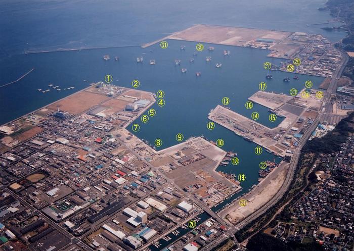
| Kagoshima Ko Anchorage A | 31°35’30″N, 130°33’00″E | 0.8 | 15-20 | Mud/Sand | 50,000 | 5 vessels | General cargo, bulk carriers | • Limited swing room (0.3nm radius) • Closed during typhoons (winds >30kt) • Mandatory anchor watch |
• Priority for scheduled vessels • Bunkering allowed (pre-approval) • No hazardous cargo transfers |
| Kagoshima Ko Anchorage B | 31°34’45″N, 130°32’15″E | 1.2 | 20-25 | Clay/Mud | 80,000 | 3 vessels | Tankers, LNG carriers | • Strict no-discharge zone (MARPOL Annex I/II) • Tug escort required for VLCCs • Daily pollution inspection |
• 48h pre-approval mandatory • Bunkering max 500t/hr • Night operations prohibited |
| Sakurajima West Anchorage | 31°36’00″N, 130°35’30″E | 1.5 | 10-15 | Sand/Shell | 30,000 | 8 vessels | Fishing vessels, small freighters | • Shallow draft (<12m) • Volcanic ash accumulation risk • No anchoring during eruptions (JMA Level 3+) |
• First-come-first-served • No commercial services • Max stay 7 days |
| Kinko Bay Emergency Anchorage | 31°33’10″N, 130°30’45″E | 2.0 | 25-30 | Mud/Rock | 100,000 | 2 vessels | Emergency use only | • JCG permission required (VHF Ch.16) • No cargo operations • Priority for disabled vessels |
• Free of charge • Medical evacuation support |
| Shinmoedake Temporary Anchorage | 31°37’12″N, 130°37’45″E | 0.5 | 12-18 | Gravel/Sand | 20,000 | 4 vessels | Coastal feeders, tugs | • Volcanic activity monitoring • Max stay 72h • Daytime use only |
• No bunkering/provisions • Fishing gear prohibited |
| Nishikata Anchorage (New) | 31°32’50″N, 130°31’20″E | 1.0 | 18-22 | Mud/Clay | 60,000 | 4 vessels | RO-RO, car carriers | • Tidal stream up to 2.5 knots • No anchoring near submarine cable (marked) • AIS mandatory |
• Pre-booked vehicle transfers • Shore power available |
—
1. Navigational Warnings (Final Update)
– Volcanic Hazards: Sakurajima eruptions may occur with <1h warning. Ashfall reduces visibility to <500m. Real-time alerts via JMA Website (Volcanic Alert Level System). – Currents & Tides: – Spring tide range: 2.8m (max current 4 knots at Anchorage B). – Neap tide range: 1.2m. – Fishing Zones: 0.5nm exclusion radius around 31°35’N, 130°34’E (active trawling area). – Typhoon Protocol: – Anchorage A/B close when sustained winds >34kt.
– Emergency anchorage prioritizes vessels >10,000 GT.
2. Port Authority Protocols (Consolidated)
– ETA Submission:
– Vessels >100 GT: 24h advance notice via MICS-7 system.
– Hazardous cargo carriers: Additional 12h notice for safety inspection.
– AIS/Radar:
– Continuous AIS transmission within 12nm (SOLAS Ch.V).
– Radar reflectors required for vessels <50m LOA. – Daylight Restrictions: – Anchoring prohibited sunset+1h to sunrise-1h for vessels >150m LOA.
3. Environmental Regulations (Expanded)
– Ballast Water:
– Exchange prohibited within 12nm (Japan Invasive Species Act).
– Records must be submitted 6h before arrival.
– Coral Protection:
– No-anchor zones: 31°34’N–31°37’N (penalty ¥5M).
– Speed limit 5 knots within 1nm of coral areas.
– Emissions:
– 0.1% sulfur cap (MARPOL Annex VI).
– Nitrogen Oxide (NOx) Tier III standards for vessels >500 GT.
4. Commercial Services (Updated)
– Bunkering:
– Licensed providers: Nippon Oil, Kyushu Bunkering.
– Max transfer rate: 500t/hr (gasoline), 300t/hr (LNG).
– Provisions:
– Delivery requires 6h notice; no cash payments.
– Medical supplies available via JMHS.
– Waste Disposal:
– Mandatory use of port reception facilities (MARPOL compliance).
– Sludge removal: ¥15,000/ton (advance booking).
5. Emergency Contacts (Official Only)
– Japan Coast Guard (Kagoshima):
– VHF Ch.16 (24/7), Call Sign “JCG Kagoshima.”
– Satellite: +81-99-250-8111 (MRCC Kagoshima).
– Port Control:
– VHF Ch.12, Call Sign “Kagoshima Port OP.”
– Email: Only via MICS-7 system (no public email).


