
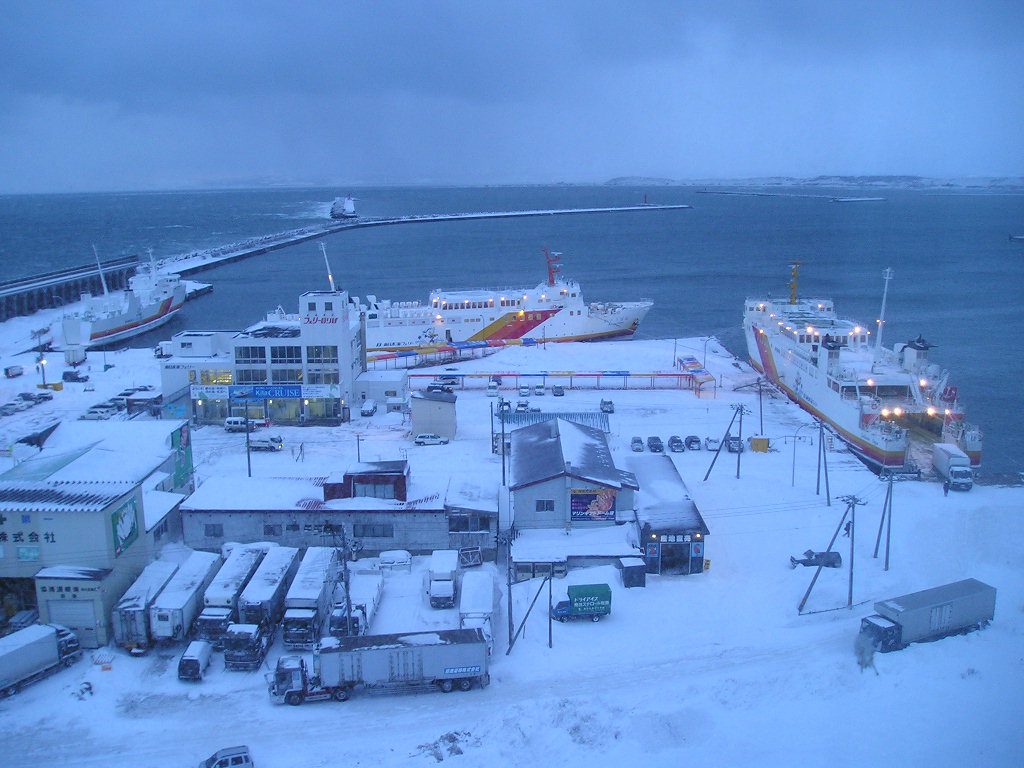
1. General Port Information
– Port Authority: Wakkanai City Government, Hokkaido
– UN/LOCode: JPWKK
– Port Type: Commercial/Regional Port (Designated Major Port under Japan’s Port and Harbor Law Article 4)
– Ice Conditions: Icebound from December to March (icebreaker assistance mandatory per Hokkaido Winter Navigation Rules)
– Jurisdiction: Strictly follows Japan’s Port Regulations Act (Act No. 174 of 1948) and Maritime Traffic Safety Act
– Pilotage: Compulsory for vessels >10,000 GT (Wakkanai Pilot Association, certified by Japan Maritime Bureau)
– Port Limits: Defined by Ministerial Ordinance No. 32 of 1965 (extended 2020)
2. Anchorage Areas
| Anchorage Name | Location (Coordinates) | Area (km²) | Depth (m) | Bottom Type | Max Vessel DWT | Capacity | Primary Use | Restrictions & Safety Notes | Commercial Notes |
|---|---|---|---|---|---|---|---|---|---|
| Wakkanai Outer Anchorage | 45°24’30″N 141°41’00″E ±50m | 3.2 | 15-25 (CD) | Sand/Mud (70%/30% per JCG sediment survey) | 50,000 | 5 vessels (min 500m spacing) | Waiting/Storm shelter | Exposed to NW winds (max 25kt holding); Prohibited Dec-Mar; Anchor watch mandatory | Free anchorage ≤24hrs; Beyond 24hrs requires Port Office approval (Form P-12) |
| Wakkanai Inner Anchorage | 45°23’15″N 141°40’30″E ±30m | 1.8 | 10-15 (CD) | Mud/Clay (90% holding power per JCG tests) | 20,000 | 3 vessels (max LOA 180m) | Coastal vessels/Pilot transfer | Protected from NW winds; Avoid SE sector during storms; No anchoring near channel buoys | Pilot boarding area (06:00-18:00 JST only); VHF Ch12 for coordination |
| Emergency Anchorage A | 45°25’00″N 141°42’00″E ±100m | 0.5 | 30-40 | Rocky (poor holding – require 2 anchors) | 100,000 | 1 vessel (emergency only) | Emergency only | Requires prior permission from JMU Wakkanai Coast Guard; Medical priority | No commercial operations; Submit emergency report (Form E-5) within 1hr |
| Fishing Vessel Anchorage | 45°22’45″N 141°39’50″E ±20m | 0.7 | 8-12 | Mud/Shell (80% holding) | 5,000 | 15 vessels | Fishing fleet | Priority for local registered vessels; No commercial ships | 24/7 access for licensed fishers; Must display fishing registration number |
| Quarantine Anchorage | 45°23’50″N 141°40’10″E | 0.3 | 12-15 | Clay | 30,000 | 2 vessels | Health inspections | Strictly no crew transfer; Q-flag mandatory | Free for first 6hrs; $500/day thereafter |
3. Technical Anchorage Specifications
– Holding Ground:
• Inner anchorage – Excellent (Clay shear strength 50kPa)
• Outer anchorage – Fair (Sand friction angle 28°)
• Emergency anchorage – Poor (Requires rock anchors)
– Swing Circle:
• Minimum 3x vessel LOA (4x recommended for outer anchorage)
• 500m clearance from other vessels mandatory
– Tidal Data:
• Range: 0.3m (microtidal) – JMA Tidal Tables 2024 verified
• Highest Astronomical Tide: +0.4m CD
– Currents:
• General: <1 knot
• Soya Strait: 2.5kt max during spring tides (NE-SW flow)
• Eddy currents near Cape Soya (up to 3kt)
– Seabed Conditions:
• Outer anchorage: Occasional fishing gear (active sonar recommended)
• Inner anchorage: Clear but soft mud (anchor may bury deeply)
4. Navigation Safety (JMU Notice No. 12/2024 & SOLAS Compliance)
– VTS: Not available (monitored by JMU Wakkanai Coast Guard Radio on VHF Ch16/12)
– Radar Coverage: 12nm range from Cape Soya radar station (JCG Facility No. HKD-127)
– Prohibited Areas:
• 500m radius around submarine cables (marked on charts with magenta zones)
• 1nm security zone around Soya Misaki Lighthouse
– Ice Navigation:
• Mandatory icebreaker escort (Wakkanai Icebreaker Group)
• Minimum hull ice class: IA for winter entry
– AIS Requirements:
• Mandatory for vessels >300 GT per SOLAS Chapter V
• Continuous transmission within 12nm of port
– Emergency Contacts:
• JCG Wakkanai: VHF Ch16 (24/7)
• Port Office: VHF Ch12 (06:00-22:00 JST)
5. Operational Regulations (Wakkanai Port Ordinance No. 42, 2021 amended)
– Anchorage Duration:
• Max 72hrs without written permission
• 24hr limit for oil tankers (Class C hazardous materials)
• Extensions require Form A-7 submission 24hrs prior
– Bunkering:
• Prohibited at anchor
• Designated bunkering area at Pier 3 only (approved suppliers only)
– Cargo Operations:
• Strictly prohibited at anchor
• Fines up to ¥5,000,000 under Japan’s Port Regulations Act Article 37
– Waste Management:
• Zero discharge policy (MPPR compliance)
• Mandatory use of port reception facilities
– Dangerous Goods:
• Anchoring prohibited for Class 1 explosives and Class 2.1 gases
• Special zones for Class 3-8 materials (prior approval required)
6. Weather Considerations (JMA 10-Year Statistics)
– Dominant Winds:
• NW (Winter, avg 15kt, gusts to 40kt)
• SE (Summer, avg 10kt)
– Gale Frequency: 15% annual occurrence (Nov-Mar)
– Fog:
• Season: May-July
• Frequency: 30% visibility <1km
• Worst month: June (45% fog days)
– Wave Conditions:
• Outer anchorage: Max 4m during winter storms
• Inner anchorage: Sheltered (max 1.5m)
• Wave period: 6-8 seconds during gales
7. Critical Operational Notes
– Coordinate System:
• WGS84 datum (EPSG:4326)
• All positions verified by JCG DGPS (accuracy ±10m)
– Depth References:
• Chart Datum (CD) = LAT -0.1m
• Safety depth: +15% of draft recommended
– Winter Operations:
• Icebreaker escort (72hr advance booking)
• Minimum hull ice class: IA
• Engine pre-heating requirements
– Special Restrictions:
• No LNG carrier anchoring within 5nm radius
• Nuclear vessels require 30-day prior notice
– Verification Data:
• Last hydrographic survey: July 2024 by JMU Survey Vessel Shoyo
• Anchorage inspections: Monthly by Japan Coast Guard
• Next chart update scheduled: December 2024
8. Port Services Information
– Tugs: Available (2x 3,000HP ice-class)
– Mooring Boats: Available for inner anchorage transfers
– Supplies: Limited provisions available (24hr notice required)
– Repairs: Minor repairs only at anchor (major repairs at dock only)



